From Republic to Sedro Woolley
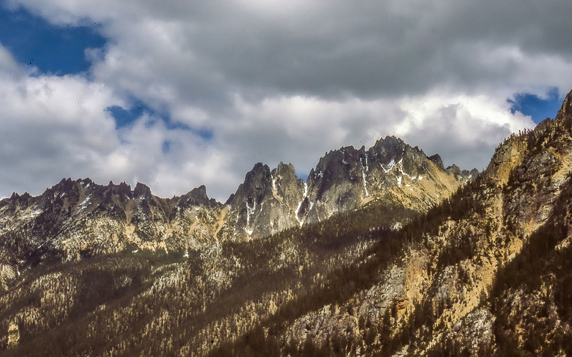
After a hearty breakfast in Republic, it’s time to set off for Sedro Woolley, on the other side of the Cascade Mountains. The map below shows only a portion of the drive as the North Cascades Highway just opened this week, and Google Maps hasn’t updated itself. It will not allow me to plot a course from Winthrop to Sedro Woolley, unless I go south and bypass North Cascades National Park. According to DistanceBetweenCities.com, following Highway 20 will add 127 miles to today’s drive. Much of that 127 miles crosses North Cascades National Park, so it will be a scenic drive. In fact, it is the only part of today’s drive for which I have photographs–scanned from slides I took over forty years ago.

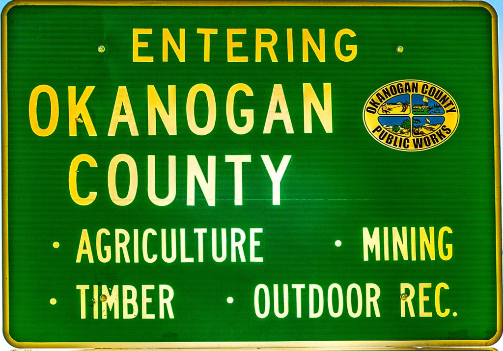
Ferry County is long and narrow, and just a few miles west of Republic, we enter Okanogan County. The largest Washington county in area, Okanogan is a mixture of mountains, lakes and fields. Much of the county’s area lies within the Colville Indian Reservation. We will miss most of the reservation, however, as we will be to the north and west. Omak, the largest city in the region, and Okanogan, the County Seat, both lie on the reservation boundary.
Driving across central Washington on roads south of Highway 20, you get the feeling that you’re never going to get out of the flat, monotonous landscape. That is not the case on Highway 20. East of Republic lies Sherman Pass, at 5,574 feet, the highest pass that Washington keeps open year round. Seventeen miles west of Republic, we’ll cross Wauconda Pass at 4,310 feet. Shortly thereafter, we’ll drive through the unincorporated town of Wauconda.
Wauconda, Okanogan County
Founded in 1898 as a gold mining camp, Wauconda grew to a peak population of nearly 1,000 before the mines gave out and the miners moved away. The townsite moved twice, most recently when Highway 20 was completed and bypassed the town. In 2010, the town went up for sale on eBay, and sold (the whole town) for $360,000. The owner later got a job in North Dakota and closed the only store in the area. No reason to stop in Wauconda today, unless we find some photogenic scenes. Eric Lacitis wrote up the story in The Seattle Times and his article Sold: 1 Tiny Town is available online.
Bonaparte Lake
After another two miles, we’ll take a short side trip to the north. Bonaparte Lake lies six miles north of Highway 20. The lake offers both a National Forest campground and a private resort, so camping, fishing, boating are all available. We are visiting just to get the lay of the land, but frankly, it sounds like a worthwhile sidetrip. The National Forest campground offers thirty campsites (26 single and 4 double) as well as a boat ramp and handicapped accessible dock. Bonaparte Lake Resort offers camping, RV parking, boat rental and a restaurant that has very tasty offerings, if I can judge by their on-line menu. Both the campground and the resort sound like great places to stay, but it’s early in the day, so we’ll head back to Highway 20 and continue on our way from Republic to Sedro Woolley.
I’m tempted to continue driving north from Bonaparte Lake, past Lost Lake to the ghost towns of Chesaw and Molson, both just south of the Canadian border. From Molson, it’s an easy drive to Oroville, which is on our itinerary. But for today, I’ll leave these towns to their ghosts, and maybe return in the future. In the meantime, I’ll direct you to my Video of the Day where HDTV visits Okanogan County, starting at Molson.
Tonasket to Omak, Okanogan County, the long way round
Back on Highway 20, we’ll drive twenty-two miles to the town of Tonasket where we’ll head north on US Highway 97. If we turned south, we’d be in Omak in half an hour, but no. We want to see more of the countryside. It’s nineteen miles from Tonasket to Oroville, the northernmost U.S. town on U.S. 97. Oroville is also at the southern end of Osoyoos Lake, a lake that does not respect the international boundary and crosses into Canada.
After stopping at Osoyoos Lake Veteran’s Memorial Park, we will take a backroad, the Loomis-Oroville Road as it follows the Similkameen River. The river flows out of British Columbia, but shortly after the river makes a 180 degree turn, we’ll drive by Palmer Lake. Continuing south through the Sinlahekin Valley, we’ll pass by Conners Lake, Forde Lake, Blue Lake, Fish Lake, and eventually arrive at Conconully Lake and the state park on the shores of Conconully. From the park, it’s a relatively straight shot to Omak and Okanogan, where we’ll continue south on U.S. 97.
Omak and Okanogan, Okanogan County
The Conconully Road actually meets U.S. 97 in Okanogan, but because I want to visit Omak, we’ll have to turn off the road a bit before its terminus. Omak, the largest city in the county, holds the Omak Stampede every August.
Yelp lists twenty-four restaurants in Omak, including most of your favorite fast-food places. But four Mexican restaurants (plus two taco trucks) show up on the list,and that would be my first choice. Two of the restaurants listed are at the 12 Tribes Resort Casino just south of town. One of three casinos operated by the Colville tribes, 12 Tribes Casino has not only restaurants and gaming, but also an RV park and spa on site.
Four miles south of Omak lies the County Seat, Okanogan. While older than Omak, Okanogan fell to second place as far as population is concerned in the early 1900s. Today, while a city in its own right, Okanogan can be considered to be a twin to Omak, and little but a boundary line separates the two cities. Yelp shows eight more restaurants in the Okanogan area, including a Thai restaurant that sounds promising.
The Lower Okanogan Valley (Okanogan to Pateros)
The thirty miles between Okanogan and Pateros follows the Okanogan River to its confluence with the Columbia. U.S. Highway 97 stays on the east side of the river while Old Highway 97 runs on the west. If we take the Old Highway, the drive will take longer, but we’ll drive through the communities of Malott and Wakefield before arriving in Brewster.
Yelp lists nine places to eat in Brewster, of which five are Mexican and two are fast-food. Of the five Mexican “restaurants,” two are groceries and one is a taco truck. However, one of my all-time favorite Yelp reviews speaks of La Milpa, a bakery and grocery store that apparently serves extraordinary sweets. The reviewer, out of Seattle, says:
Where I find all my Mexican munchies after some “Acapulco Gold.” And I’m not just talking about frijoles and chiles.
I want pan dulce, ganzitos, sabritas, jumex, candy, and all my lead injected imports!
He closes with: “I’m taking one star off for having their favorite soccer team’s memorabilia plastered throughout the store, yuk, even on their business cards. I almost didn’t take a card. I just hate the team.” I guess I’ll have to stop by to find out which soccer team the reviewer hates. He gave the place four stars, btw.
Seven miles further along U.S. 97, and we’ll turn north and west on Washington 153 at Pateros. Yelp lists a few restaurants in Pateros, but Trip Advisor shows five, including two Filipino places. This probably should not surprise us as the town’s name comes from a village in the Philippines. This is the southern-most point on our drive from Republic to Sedro Woolley. Pateros lies at the confluence of the Methow and Columbia Rivers, and from here we’ll follow the Methow upstream and into the North Cascades.
The Methow Valley
Driving on Washington Highway 153, we will climb from 804 feet above sea level to 1,768 feet at Winthrop. Eventually, we’ll top out at 5,476 feet at Washington Pass and four miles further we’ll cross Rainey Pass at 4,875. I won’t go into detail about the Methow Valley as today’s Guest Site of the Day does exactly that. CascadeLoop.com devotes one segment to Discover the Methow Valley. The only two towns on this segment are Twisp and Winthop, both worth visiting as we travel from Republic to Sedro Woolley.
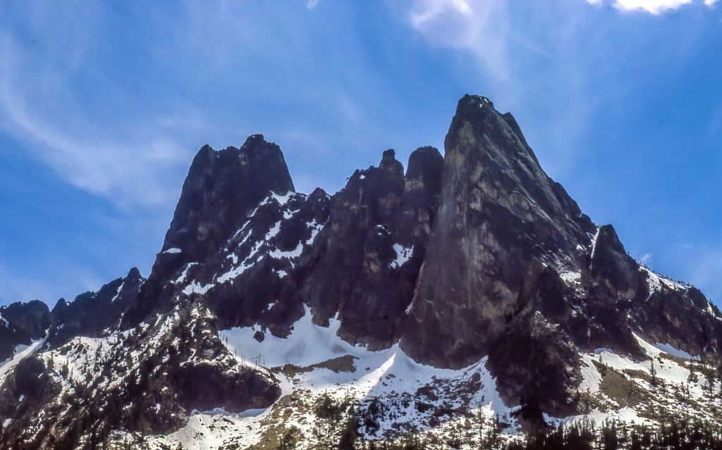
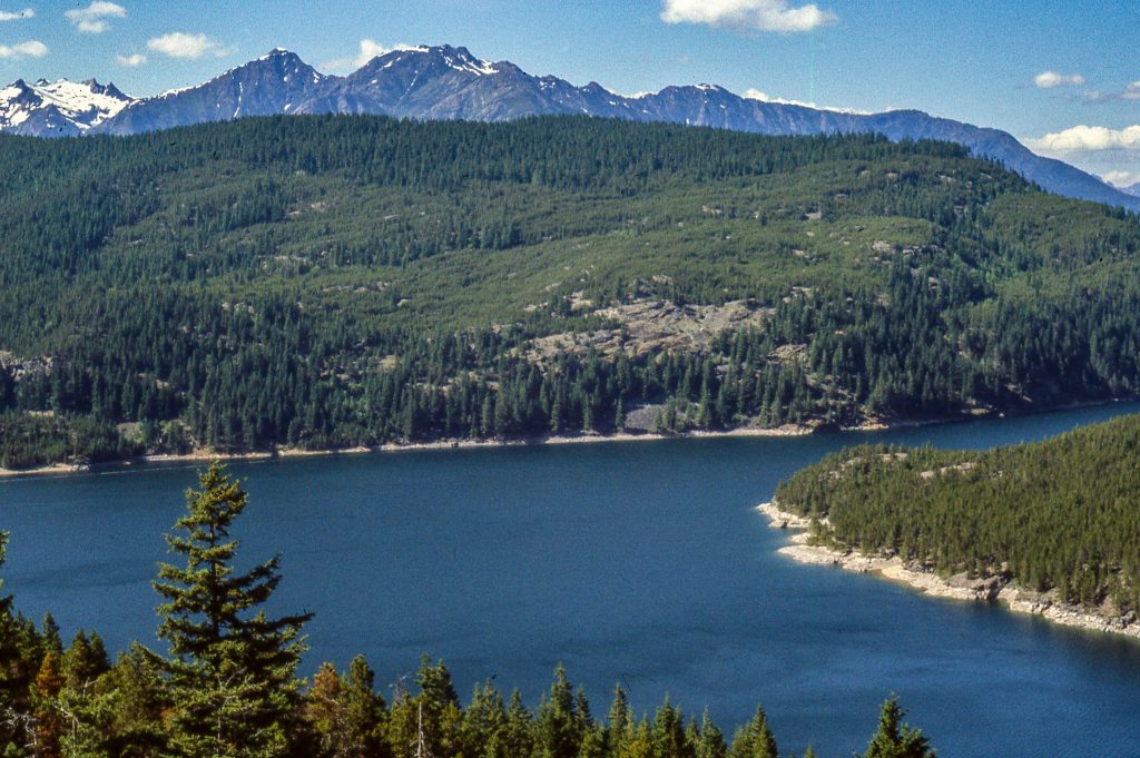
North Cascades National Park
Liberty Bell Mountain rises above Highway 20 at the Washington Pass Overlook. Crossing the pass, we also cross over from Okanogan to Chelan County. Mike McQuaide, writing in the Seattle Times, says that this “is the pivot point where Western Washington becomes Eastern Washington.” Of course, we’re going in the opposite direction, driving from Republic to Sedro Woolley.
Four miles further on, we cross Rainey Pass and the Pacific Crest Trail, and leave Chelan County for Skagit County. In another ten miles we leave Skagit County and enter Whatcom County. We are now fully in the northern end of the Cascade Mountains, but not in the National Park. Highway 20 runs through a corridor that separates the North Unit from the South Unit of the park. In a rather byzantine way, four continguous units were created by the National Park Service on October 2nd, 1968. Those four units are the the Park’s North Unit, Ross Lake National Recreation Area, the Park’s South Unit and Lake Chelan National Recreation Area.
Highway 20 runs through the Lake Ross NRA, the only paved highway in the entire park complex. Wikipedia tells us that 93% of the total complex lies within the Stephen Mather Wilderness. For a long, but fascinating read on the machinations that led to the creation of the North Cascades Complex, I recommend David Louter’s 1998 work Contested Terrain: North Cascades National Park Service Complex, Washington
An Administrative History. (Available on-line at the link above.)
Ross Lake National Recreation Area
Here’s the overly simplified rationale for the separation of the North and South Units of North Cascades National Park. Seattle City Light, the publicly owned utility supplying power to Seattle, had built three dams on the Skagit River. The company didn’t want those dams impacted by a National Park. In truth, there are many other reasons for the unusual configuration of the park complex. I recommend Louter’s work (above) if you want to really get into the nitty-gritty.
The completion of Highway 20 across the North Cascades also made the creation of Ross Lake NRA attractive, as the park itself could be kept wilderness. As near as I can determine, the only other road in the park complex lies in the Lake Chelan NRA at the southern end of the park.
The Skagit River Valley
The last forty-five miles of today’s drive follow the course of the Skagit River from Ross Lake on. We are nearing the end of our drive from Republic to Sedro Woolley. But we have a few more sights to see along the way. In addition to Ross Dam, Seattle City Light built two more dams on the Skagit. Both Diablo and Gorge Dam are worth stopping for, as is the community of Newhalem.
Author Tobias Wolff grew up in Newhalem and describes it in his autobiographical memoir This Boy’s Life. In the book, he has renamed the town Chinook. Newhalem is also home to Old Number 6, a 2-6-2 locomotive built for Seattle City Light. Anyone interested in rail history will appreciate stopping for a visit.
Skagit County
A few miles beyond Newhalem, we enter Skagit County, the last county line we’ll cross today. We’ll drive through the Skagit County communities of Rockport, Concrete, and finally arrive at Sedro Woolley. Sedro Wooley calls itself the Gateway to the North Cascades and is the largest town we’ve seen today. We’ll spend the night here before heading on down Highway 20 to Anacortes and the San Juan Islands.
And that’s it for today
Our drive from Republic to Sedro Woolley has been a long, but scenic drive. We could have taken a shorter route, eliminated some of the scenery, but hey. It’s a fantasy road trip. I planned for 300 mile days and this has been closer to 350, but we’ll survive. Get a good night’s rest, cause tomorrow is another day. (That sounds familiar.)
TTFN
![]()
Ihr Blog ist ein Erfolg, sehr voll. Ahhh Wenn die Leidenschaft da ist, ist alles 🙂 Britteny Miles Ruthy
Danke sehr!
Its such as you read my thoughts! You appear to know so much approximately this, such as you wrote the e book in it or something. I feel that you just could do with a few percent to power the message home a little bit, but other than that, that is wonderful blog. A fantastic read. Ill certainly be back. Olympe Rockwell Barrett
Thank you for your kind comments and suggestions.